
A floodplain development permit is an official authorization required before any construction, grading, or land alteration within a designated flood hazard area. Missouri property owners and developers working near rivers, streams, or low-lying areas must secure this permit before breaking ground. The permit operates under the National Flood Insurance Program (NFIP), the federal framework that ties local compliance to community access to flood insurance and disaster aid. Skipping this step carries serious consequences: stop-work orders and legal penalties can halt a project mid-construction and expose you to significant financial liability.
Who needs a floodplain development permit?
Any property owner, developer, or contractor performing work within a Special Flood Hazard Area (SFHA) needs a floodplain development permit. The SFHA is the land FEMA identifies as having a 1% or greater annual chance of flooding, commonly called the 100-year floodplain. Missouri has extensive SFHA coverage along the Missouri River, Mississippi River, and their tributaries, making this requirement relevant to a large share of the state's developable land.
The permit covers a wider range of activities than most developers expect. Construction, land clearing, grading, or fill placement within an SFHA all require a permit before work starts. The full list includes:
- New building construction and additions
- Grading, excavation, and fill placement
- Land clearing and vegetation removal
- Mining, dredging, and channel modifications
- Utility installations, including pipelines and drainage infrastructure
- Placement of manufactured homes or temporary structures
One distinction matters here. A floodplain development permit is separate from a standard building permit and does not substitute for one. The floodplain permit confirms compliance with flood hazard ordinances specifically. Elevation and floodproofing standards are reviewed independently. You will typically need both permits before construction can proceed legally.
Jurisdictional authority adds another layer. Missouri counties and municipalities administer floodplain regulations locally, but they must meet or exceed NFIP minimum standards set by FEMA. Some jurisdictions, particularly those in the Community Rating System (CRS), impose stricter requirements. Checking with your local floodplain administrator before submitting any application saves time and prevents costly rework.

What does the floodplain development permit application process look like?
The permit process follows five defined phases. Understanding each phase helps you build a realistic project schedule and avoid the documentation gaps that cause the most delays.
-
Application submission. You submit a completed application with supporting documents to your local floodplain administrator. Required materials typically include site plans, a legal property description, and a description of the proposed work. Some jurisdictions also require a preliminary flood risk assessment at this stage.
-
Technical review. The floodplain administrator reviews your submission against local ordinances and NFIP standards. Documentation includes site plans, flood insurance studies, and elevation certificates. Projects in or near a regulatory floodway trigger additional engineering review.
-
Permit issuance. Once the review is complete and all requirements are satisfied, the permit is issued. The permit card must be posted visibly on site throughout construction.
-
Construction inspections. Routine inspections occur at defined milestones during construction. Inspectors verify that work matches the approved plans and that elevation requirements are being met as the structure takes shape.
-
Final compliance and documentation. A post-construction elevation certificate prepared by a licensed surveyor is required before the permit closes out. This document confirms the finished structure meets required elevation and floodproofing standards.
Projects located in a regulatory floodway face an additional requirement. A No-Rise Certification must be prepared by a licensed engineer to demonstrate that the proposed development will not increase base flood elevations. This engineering analysis involves hydrologic and hydraulic modeling and can add weeks or months to the review timeline.
Incomplete applications cause rejection or significant delays. Many Missouri jurisdictions offer pre-submittal review meetings to help applicants identify missing items before the formal submission. Taking advantage of that option is one of the most effective ways to keep a project on schedule.
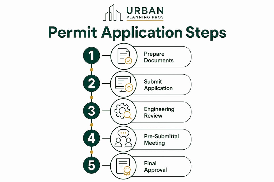
Pro Tip: Request a pre-submittal meeting with your local floodplain administrator before you finalize your application package. Identifying missing documents early can shave weeks off your review timeline.
How does floodplain zoning affect permit requirements?
Flood zone designation is the single biggest factor in determining how complex and costly your permit process will be. FEMA's Flood Insurance Rate Maps (FIRMs) divide flood-prone land into zones with different risk levels and regulatory requirements. Understanding where your property falls on the FIRM before you commit to a project is a non-negotiable step in any feasibility study stages process.
The two most important distinctions are between the floodway and the flood fringe. The regulatory floodway is the channel of a river plus the adjacent land needed to carry the base flood without raising water levels. The flood fringe is the remaining SFHA outside the floodway. Development standards differ significantly between these two areas.
| Zone type | Typical permit requirements | Engineering demand |
|---|---|---|
| Flood fringe (AE zone) | Elevation certificate, standard site plan | Moderate |
| Regulatory floodway | No-Rise Certification, hydraulic modeling, engineer stamp | High |
| VE zone (coastal) | Elevation certificate, breakaway wall design, engineer stamp | Very high |
| Zone X (minimal risk) | Usually no floodplain permit required | Low |
Fringe zones may have streamlined processes, while VE or AE regulatory floodway zones require detailed engineering and modeling. That added complexity can add months to project timelines. For Missouri developers working along the Missouri or Mississippi River corridors, floodway designations are common, and the No-Rise Certification requirement is the rule rather than the exception.
Base Flood Elevation (BFE) is the reference point for all elevation requirements. Structures must be built at or above the BFE, and many local ordinances require freeboard, meaning additional height above the BFE, as an extra safety margin. Development in the floodway is highly restricted, and any increase in base flood elevation is generally prohibited to protect upstream and downstream property owners.
Key factors that drive permit complexity include:
- Proximity to the regulatory floodway boundary
- Whether fill placement will displace flood storage volume
- The size and footprint of the proposed structure
- Local freeboard requirements above the BFE
- Whether the FIRM has been recently updated or is under revision
What are the key compliance requirements after permit approval?
Permit approval is not the finish line. Post-approval compliance obligations are just as important as the application itself, and failing to meet them can result in permit revocation or denial of a certificate of occupancy.
Post-construction elevation certificates prepared by licensed surveyors are required before final permit closeout. These certifications confirm that the finished structure meets required elevation and floodproofing standards. Lenders, insurers, and municipal records all rely on this document. A missing or inaccurate elevation certificate can block a property sale, delay financing, or inflate flood insurance premiums for the life of the structure.
Routine construction inspections occur throughout the build. Inspectors check that the foundation elevation matches the approved plans, that fill placement stays within permitted limits, and that no unauthorized changes have been made to the site. Any deviation from the approved plans requires a permit amendment before work continues.
Ongoing compliance obligations include:
- Posting the permit card visibly on site at all times during construction
- Notifying the floodplain administrator before each inspection milestone
- Maintaining copies of all approved plans on site for inspector review
- Submitting a final as-built survey if site conditions changed during construction
- Retaining all permit documents, elevation certificates, and inspection reports permanently
Pro Tip: Keep a dedicated project file with every permit document, inspection report, and elevation certificate. Future buyers, lenders, and insurers will request this documentation, and gaps in the record create real problems at closing.
Knowing the distinct roles of building permits, elevation certificates, and engineering certifications accelerates compliance. Treating them as a coordinated package rather than separate tasks reduces the risk of missing a deadline or submitting an incomplete closeout package.
Key Takeaways
A floodplain development permit is a mandatory, multi-phase approval tied to NFIP standards, and missing any phase, from No-Rise Certification to post-construction elevation surveys, can stop a Missouri project cold.
| Point | Details |
|---|---|
| Permit scope is broad | Construction, grading, fill, and utility work in an SFHA all require a permit before work starts. |
| Floodway triggers extra steps | Projects in a regulatory floodway must submit a No-Rise Certification from a licensed engineer. |
| Zone designation drives complexity | VE and AE floodway zones require hydraulic modeling and can add months to the review timeline. |
| Post-construction survey is mandatory | A licensed surveyor must prepare an elevation certificate before the permit closes out. |
| Incomplete applications cause delays | Pre-submittal meetings with the floodplain administrator reduce the risk of rejection. |
What I've learned about floodplain permits after years in the field
The biggest mistake I see property owners make is treating the floodplain development permit as an afterthought. They finalize a site plan, price out construction, and then discover the property sits in a regulatory floodway. At that point, the No-Rise Certification requirement can reshape the entire project design or kill the timeline entirely.
The second most common mistake is underestimating how much the flood zone designation changes the cost equation. A project in a flood fringe zone and a project in a regulatory floodway may look identical on paper, but the engineering demands are completely different. No-Rise Certifications act as technical bottlenecks that are non-negotiable. Budgeting for them late in the process is a painful and avoidable error.
My consistent advice: pull the FIRM for your property before you do anything else. Confirm the zone, identify the BFE, and talk to the local floodplain administrator early. That conversation costs nothing and can save you months. The permit process is not designed to block development. Floodplain permit processes prioritize harm reduction over outright prohibition, and administrators generally want to help applicants succeed. The developers who move fastest are the ones who come in prepared, not the ones who push back against the process.
— Jeremy
How Urbanplanningpros supports floodplain permit compliance
Floodplain permitting involves coordinating site plans, engineering certifications, elevation surveys, and local ordinance requirements across multiple phases. Missing one piece delays the entire project.

Urbanplanningpros works with Missouri property owners and developers to evaluate floodplain constraints before they become project-stopping problems. From feasibility studies that identify flood zone designations and BFE requirements early, to engineering services that support hydrologic analysis and No-Rise Certification preparation, the team brings the technical and regulatory expertise your project needs. Urbanplanningpros also provides expert project management to coordinate permit phases, inspection scheduling, and documentation so nothing falls through the cracks. Contact Urbanplanningpros to get a clear picture of what your floodplain project requires before you commit capital.
FAQ
What triggers the need for a floodplain development permit?
Any construction, grading, fill placement, or land clearing within a Special Flood Hazard Area triggers the permit requirement. The rule applies to all communities participating in the NFIP, which includes nearly every Missouri municipality.
What is a No-Rise Certification?
A No-Rise Certification is an engineering analysis, prepared by a licensed engineer, that proves a proposed project will not increase base flood elevations in a regulatory floodway. It is a federal standard strictly enforced by local ordinances.
How long does the floodplain permit process take?
Timeline varies by flood zone and project complexity. Fringe zone projects with complete documentation can move through review in a few weeks. Floodway projects requiring hydraulic modeling and No-Rise Certification can take several months.
Is a floodplain development permit the same as a building permit?
No. A floodplain development permit confirms compliance with flood hazard ordinances specifically. It does not replace a standard building permit, and most projects require both before construction can legally begin.
What happens if I build without a floodplain development permit?
Building without a permit can result in stop-work orders, fines, and legal penalties. It can also jeopardize the community's NFIP participation, which affects every resident's access to federal flood insurance and disaster aid.