Floor area ratio (FAR) is the ratio of a building's total floor area to the size of its lot, and it sets the outer limit on how much you can legally build on a piece of land. A parcel with a FAR of 2.0 can support a building with twice its lot area in total floor space, whether that means two full floors covering the whole lot or four floors covering half of it. The exact rules for what counts vary by jurisdiction, so the number alone never tells the whole feasibility story.
TL;DR:
- Most jurisdictions limit buildable floor area through FAR, but local rules on lot and floor measurements often cause miscalculations, leading to costly errors.
- FAR is a volume measure that allows multiple building configurations, but height, setbacks, and coverage rules may prevent fully reaching the maximum FAR allowance in practice.
- Bonus FAR incentives are typically available for affordable housing, public benefits, or sustainability features, but require early application and confirmation of local program eligibility.
- Accurate FAR calculation demands precise measurements, understanding exclusions, and checking local definitions to avoid overestimating developable space and risking permit issues.
- Using FAR as an early feasibility tool helps identify site constraints, potential build volume, and value opportunities before committing to a design or purchase decision.
Table of Contents
- What Is Floor Area Ratio and What Formula Defines It?
- How Do I Calculate Floor Area Ratio?
- What Square Footage Counts Toward FAR?
- How Does FAR Interact With Height Limits and Setbacks?
- What Impact Does FAR Have on Density and Land Value?
- Where Do FAR Calculations Go Wrong Across Jurisdictions?
- How Do You Use FAR in an Early Feasibility Check?
- Why Do Cities Regulate Floor Area Ratio in the First Place?
- How Does FAR Compare to Floor Space Index and Other Metrics?
- How Does FAR Shape a Neighborhood's Character?
- How Do You Request or Negotiate a FAR Bonus?
- How Does FAR Connect to Environmental and Sustainability Goals?
- Planner Perspective: The FAR Mistakes That Actually Cost Money
- How Urban Planning Pros Turns FAR Math Into a Buildable Plan
- Where to Verify Local FAR Rules
- Sources
- FAQ
What Is Floor Area Ratio and What Formula Defines It?
FAR is calculated with one formula: FAR = gross floor area ÷ lot area. If a building contains 20,000 square feet of floor space on a 10,000 square foot lot, the FAR is 2.0, which planners also write as a ratio of 2:1. Both notations describe the same relationship between built space and land.
You'll see this metric under different names depending on where you're working. Some codes call it floor space index (FSI), others use plot ratio, and the concept behind all three terms stays the same: total floor area measured against total lot area, expressed as a single number that ignores how the building is shaped. Wikipedia's overview of the metric confirms this cross-jurisdictional naming pattern and notes that FSR and FSI are functionally interchangeable with FAR.
Here's the part that trips up a lot of first-time developers: FAR describes volume, not form. A 2.0 FAR lot could carry a squat two-story building covering the entire parcel, or a slender four-story tower covering half of it. The number tells you how much floor space is legally allowed. It says nothing about height, footprint, or where the building sits on the lot. That's why FAR always works alongside other zoning tools, which we'll get to shortly.
How Do I Calculate Floor Area Ratio?
Calculating FAR correctly takes four steps, and skipping the first one is where most estimate errors start.
- Confirm your lot area. Pull the exact square footage from your survey or plat map, and check whether the jurisdiction uses gross lot area or a "developable" area that excludes easements, right-of-way dedications, or environmentally sensitive land.
- Measure gross floor area. Add up the horizontal floor area on every level the local code counts, using exterior wall measurements unless your jurisdiction specifies otherwise.
- Divide floor area by lot area. The result is your FAR, expressed as a decimal or ratio.
- Cross-check against the zoning cap. Compare your calculated or proposed FAR against the maximum allowed in that zoning district before you commit to a design direction.
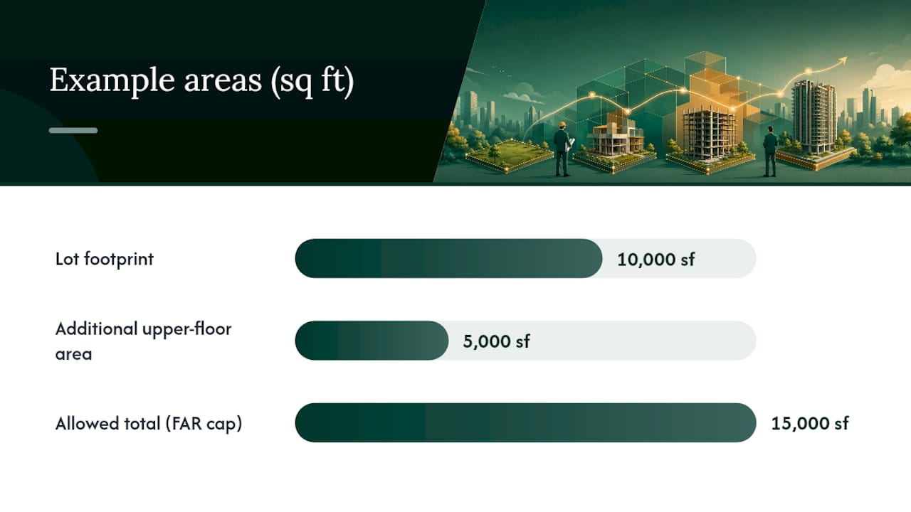
A worked example makes this concrete. Say you own a 10,000 square foot lot zoned for a maximum FAR of 1.5. That ceiling allows 15,000 square feet of total floor area. You could build a single-story structure covering the full lot at 10,000 square feet, then add a partial second floor of 5,000 square feet to reach the cap. Or you could build a three-story structure with a smaller footprint, 5,000 square feet per floor, and hit the same 15,000 square foot limit. Investopedia's calculation walkthrough uses a similar approach to show how the same FAR supports multiple building configurations.
Pro Tip: Keep your lot area and floor area measurements in the same unit basis throughout the calculation. Mixing gross lot acreage with net floor area in square feet is one of the fastest ways to hand a lender or planning department a FAR number that doesn't hold up under review.
What Square Footage Counts Toward FAR?
Local codes rarely count every enclosed square foot on a property, and the gaps between what you'd assume and what actually qualifies can swing a feasibility number significantly.
Most jurisdictions include:
- Gross horizontal floor area on all habitable or occupiable levels
- Mezzanines, when they exceed a minimum size threshold set by local code
- Interior common areas like hallways and lobbies in many commercial contexts
Most jurisdictions exclude:
- Parking garages and dedicated parking structures
- Unoccupied mechanical floors, equipment rooms, and elevator shafts
- Certain basement levels, particularly those used solely for parking or storage
Wikipedia's breakdown of standard exclusions lists mechanical floors and parking structures as the most commonly excluded categories, though the specifics shift from one zoning code to the next. Before you finalize any FAR-based projection, verify the local zoning definition directly. A calculation built on assumptions borrowed from a neighboring county can be off by a meaningful margin once the actual code is applied.
How Does FAR Interact With Height Limits and Setbacks?
FAR sets a ceiling on total floor area, but it rarely operates alone. Building coverage ratio (BCR) caps how much of the lot footprint a structure can occupy, which is a different constraint entirely. A lot might allow a FAR of 2.0 but a BCR of 40%, meaning you can't simply spread that floor area across the whole parcel. You'd need to build taller on a smaller footprint to use your full FAR allowance.
Height limits and required setbacks can prevent a project from ever reaching its numeric FAR ceiling in practice. A five-story height cap combined with generous side yard setbacks might make the mathematically allowed FAR physically impossible to build. This is exactly why municipalities pair FAR with premiums or bonus provisions. When a jurisdiction wants to encourage a specific outcome, like a public plaza or affordable units, it grants extra FAR as an incentive that developers can only unlock by delivering that public benefit.
What Impact Does FAR Have on Density and Land Value?
Raising the FAR ceiling on a parcel increases the potential building volume it can support, and that additional capacity tends to raise the land's market value because buyers are purchasing development rights, not just dirt. Lower FAR caps restrict how much floor area a site can hold, which constrains supply and can push land values in the opposite direction, according to Harvard's Graduate School of Design research on missing-middle housing.
Jurisdictions use FAR deliberately as a policy lever rather than a fixed ceiling. Washington State's HB 1491, passed in 2025, requires local governments to set minimum FAR standards near transit stations specifically to unlock more housing capacity in transit-oriented development zones, according to MRSC's analysis of the law. Many cities also offer FAR bonuses tied to affordable-housing set-asides, letting a developer build beyond the base cap in exchange for including below-market units. For a landowner evaluating a site, understanding whether a parcel sits inside one of these bonus or minimum-density overlays can change the feasibility math substantially.
Where Do FAR Calculations Go Wrong Across Jurisdictions?
No two zoning codes define floor area or lot area identically, and that inconsistency is where most costly miscalculations start. One city might exclude below-grade parking entirely; the next might only exclude it if the parking serves the building's own residents. MRSC's guidance on FAR stresses that relying on a general definition instead of the specific local resolution is one of the most common and expensive planning mistakes.
Common pitfalls include:
- Mixing gross lot area with developable area after subtracting easements or right-of-way
- Miscounting mezzanines or basements that fall just above or below a local size threshold
- Overlooking overlay districts that adjust the base FAR up or down for a specific sub-area
- Missing bonus provisions that would have allowed more buildable area than the base zoning suggests
Pro Tip: Before you run a single feasibility number, pull the exact zoning resolution section covering FAR definitions for your parcel, request the most recent survey, and call the local planning office to confirm whether any overlay district or bonus program applies. That one phone call routinely surfaces details a desktop review misses.
How Do You Use FAR in an Early Feasibility Check?
The fastest way to test a site's potential is a simple conversion: FAR × lot area = maximum gross floor area (GFA). A 15,000 square foot lot at a 2.0 FAR yields 30,000 square feet of maximum GFA. From there, you can rough out unit count or leasable area by dividing that GFA by a typical unit size or by a per-square-foot leasing benchmark for the asset type.
That first-pass number is only a starting point. Parking requirements can eat into your buildable envelope before you ever touch the FAR ceiling. Setbacks and unit mix assumptions change how efficiently you can actually use the allowed floor area, and construction cost sensitivity determines whether the maximum FAR is even worth pursuing financially. When any of these variables start working against each other, that's the signal to bring in a planner or feasibility consultant rather than continuing to build the pro forma on assumptions. A proper feasibility engagement typically starts with a zoning and site constraint review before moving into massing studies and cost benchmarking.
Why Do Cities Regulate Floor Area Ratio in the First Place?
FAR as a planning tool traces back to early twentieth-century zoning reform, when cities like New York began grappling with how to control building bulk without banning tall buildings outright. Before FAR-style ratios existed, height and setback rules alone struggled to prevent overcrowded, light-starved streets, since a builder could still construct a massive floor plate at a modest height. Floor area ratio solved that by tying total floor space directly to lot size, giving regulators a single number that scaled with the parcel rather than an arbitrary height cap applied uniformly across different lot sizes.
The rationale has stayed remarkably consistent across a century of use: FAR lets a jurisdiction manage the total intensity of development on a site while leaving the architect room to decide how that volume gets shaped. A city can set a FAR of 1.0 in a low-density residential zone and a FAR of 10.0 or higher in a central business district, calibrating development intensity block by block without writing a separate height rule for every zone.
Modern zoning codes have layered additional goals onto that original bulk-control function. Municipalities now use FAR to steer growth toward transit corridors, protect low-density residential character in outlying neighborhoods, and create negotiating room for public-benefit bonuses. The NYC Zoning Resolution still organizes its FAR tables by district precisely because the original logic holds: match allowed bulk to the infrastructure and character each area can support. What started as a blunt anti-congestion tool has become one of the most flexible levers in a planner's toolkit.
How Does FAR Compare to Floor Space Index and Other Metrics?
Floor space index (FSI) and FAR are the same calculation wearing different regional names. FSI shows up most often in codes influenced by British or Commonwealth planning traditions, while FAR dominates in most American zoning language, but both divide total floor area by lot area and produce an identical number. If you're comparing development potential across markets that use different terminology, don't assume a difference in naming signals a difference in method. Confirm the formula each code actually uses before treating the numbers as directly comparable.
Building coverage ratio (BCR) is a genuinely different metric, not just a regional synonym. BCR measures footprint, the percentage of the lot a building's ground floor occupies, while FAR measures total floor area across every level. A site can carry a low BCR and a high FAR simultaneously if the building rises tall on a small footprint, or a high BCR and low FAR if it spreads low and wide across the lot.
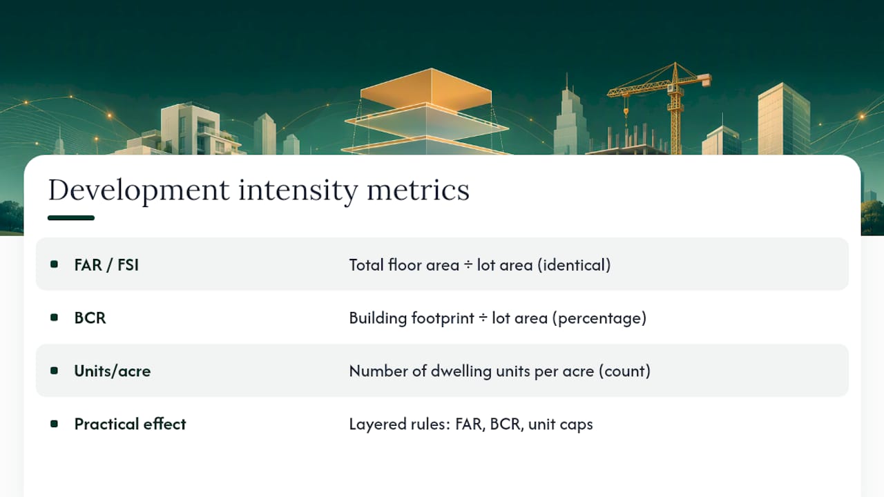
Density metrics like units per acre serve a related but distinct purpose. Where FAR measures floor area regardless of how it's divided into units, units-per-acre caps regulate the number of dwelling units directly, independent of their size. A code might allow a generous FAR but still cap unit count, which pushes developers toward larger units rather than more of them. Research using satellite imagery to analyze building density patterns treats FAR and BCR as complementary measurements, since neither one alone captures the full picture of how intensively a parcel is developed. For a landowner sizing up a site, knowing which metric actually governs the parcel, and which ones layer on top of it, prevents a nasty surprise late in design.
How Does FAR Shape a Neighborhood's Character?
FAR is one of the more powerful, and more invisible, tools shaping how a street actually feels to walk down. Two neighborhoods with identical zoned FAR can look completely different once BCR, height limits, and setback rules are layered on top, which is exactly why FAR by itself can't predict neighborhood character on its own.
A low FAR paired with generous lot coverage produces the sprawling, low-rise pattern typical of many suburban commercial strips: wide buildings, minimal height, parking-dominated sites. Raise the FAR while tightening the BCR and setback requirements, and you get the opposite pattern, taller and narrower buildings that leave more open or landscaped space at grade. Downtown districts with FAR values reaching into the double digits produce the dense, tower-heavy skylines associated with major central business districts, while surrounding residential zones might carry FAR caps under 1.0 to preserve a lower-scale streetscape.
This is precisely why FAR changes generate so much public debate at city council meetings. A proposed FAR increase in a residential district isn't just a number on a zoning map. It's a signal that taller, bulkier buildings could eventually replace the existing scale of the block, and neighbors tend to notice that shift long before it happens. Planners who understand this dynamic often pair FAR increases with design standards, stepbacks, or transition zones at district edges specifically to soften the visual jump between old and new development intensity.
How Do You Request or Negotiate a FAR Bonus?
FAR bonuses aren't automatic. You typically have to identify the program that applies to your parcel and structure your project to qualify for it before you can claim the extra buildable area.
Start by checking whether your site sits inside an overlay district or a designated bonus zone, since many jurisdictions administer FAR premiums through these geographic layers rather than granting them citywide, according to MRSC's guidance on local FAR programs. Affordable-housing set-asides are among the most common qualifying paths: commit a percentage of units to below-market rents, and many codes will grant additional FAR in return, sometimes substantial enough to change a project's entire scale.
Public-benefit bonuses work similarly. Providing a publicly accessible plaza, preserving a historic facade, or contributing to a transit improvement can unlock a negotiated FAR increase, though the process usually requires a formal application, a public hearing, or a discretionary review rather than a simple permit request. Variances follow a different track entirely: rather than qualifying for a published bonus program, you're asking the zoning board to grant relief from the base FAR cap based on a hardship specific to your parcel, such as an irregular lot shape that makes the standard cap impractical to use.
The practical move for a landowner is to scan for these bonus and variance pathways early, before committing to a design based only on the base FAR. Missing an available bonus program means potentially leaving significant buildable area, and project value, on the table.
How Does FAR Connect to Environmental and Sustainability Goals?
Concentrating floor area on fewer, better-located parcels is one of the more direct ways zoning policy touches climate and resource outcomes, and FAR is the metric doing most of that work. Higher FAR near transit and job centers supports the kind of compact, walkable development that reduces vehicle miles traveled compared to the same population spread across a low-density, car-dependent footprint.
That's part of the logic behind HB 1491 in Washington State, which ties minimum FAR requirements to proximity to transit stations specifically to concentrate growth where infrastructure already exists rather than pushing it outward into undeveloped land. Concentrating development this way also tends to reduce per-unit infrastructure costs, since roads, utilities, and transit service all become more efficient to provide at higher density.
FAR bonuses increasingly get tied to sustainability performance as well. Some jurisdictions now offer additional FAR in exchange for green roofs, stormwater management features, or energy-efficiency benchmarks that exceed baseline code. For a landowner or developer, this means the environmental angle isn't just a compliance checkbox. It can be an active lever for unlocking more buildable area, provided the site and project type make those sustainability features financially workable within the broader construction budget.
Planner Perspective: The FAR Mistakes That Actually Cost Money
The single most expensive habit we see is teams locking in a design before confirming how the local code defines gross floor area. One near-miss involved a client whose pro forma assumed a below-grade parking exclusion that the local jurisdiction didn't actually grant, a gap that would have shrunk the buildable area significantly if it had surfaced after permitting instead of before. Run at least two FAR scenarios early, one conservative and one liberal on inclusion rules, before you commit capital to design.
— Jeremy Wenger
How Urban Planning Pros Turns FAR Math Into a Buildable Plan
Running the FAR numbers yourself gets you a starting estimate. Turning that estimate into a permit-ready, financeable project is where most landowners hit a wall, and it's exactly where Urban Planning Pros steps in. Our feasibility studies confirm your parcel's actual zoning definition of floor area, check for overlay districts or bonus programs before you leave value on the table, and coordinate survey and engineering work so your FAR calculation holds up under real permitting scrutiny, not just a desktop review.

A typical engagement starts with a scoped review of your zoning classification, lot constraints, and any applicable premiums, then delivers a clear picture of maximum buildable floor area alongside the practical limits that height, setbacks, and coverage rules impose on top of it. That combination catches costly surprises before they show up mid-design. For larger or multi-parcel sites, our master land planning services extend that same FAR-based framework across a full site plan. If you're weighing a purchase, a sale, or a ground-up build, book a feasibility study before you finalize a design direction.
Where to Verify Local FAR Rules
Check your municipality's zoning resolution directly for the final word on FAR definitions and caps. The NYC Zoning Resolution and MRSC's FAR guidance are strong models for how local codes structure these rules, and Wikipedia's overview offers a solid plain-language starting point. For zoning due diligence beyond FAR alone, this overview of must-know zoning regulations covers related site considerations worth checking early.
Sources
- Floor area ratio — Wikipedia
- Floor Area Ratio: What It Is and How Local Governments Can Use It — MRSC
- Understanding floor area ratio (FAR) — Investopedia
- NYC Zoning Resolution — Article II, Chapter 3 (Floor area ratio examples)
FAQ
How Do I Calculate Floor Area Ratio?
Divide the building's total gross floor area by the lot's area. A building with 20,000 square feet of floor space on a 10,000 square foot lot has a FAR of 2.0.
What Does a Floor Area Ratio of 2.0 Mean?
It means the lot can support up to twice its own area in total floor space, distributed across any number of stories, as long as height limits, setbacks, and coverage rules allow it.
Is a Higher Floor Area Ratio Always Better?
Not necessarily. A higher FAR generally increases buildable area and land value, but height limits, setbacks, parking requirements, and construction costs can prevent a site from ever using its full FAR allowance profitably.
What's Typically Excluded From a FAR Calculation?
Most codes exclude parking garages, unoccupied mechanical floors, and certain basement levels, though exact exclusions vary by jurisdiction and should always be confirmed against the local zoning resolution.
When Should I Bring in a Feasibility Consultant for a FAR-Based Project?
Bring in a consultant as soon as your FAR-based estimate needs to survive real financing or permitting scrutiny, particularly if the site sits in an overlay district, a bonus zone, or has irregular lot geometry that complicates the base calculation.