Residential density equals the number of dwelling units divided by the site area in acres, using the standard 43,560 square feet per acre conversion. That gives you the theoretical yield allowed under a zoning code. The real number you can build almost always comes in lower, once easements, rights-of-way, setbacks, and parking requirements take their share of the site.
TL;DR:
- Most sites' actual buildable units are significantly reduced by easements, right-of-way dedications, setbacks, parking, and environmental constraints not accounted for in simple density calculations.
- Gross versus net density measures can differ substantially, especially on sites with wetlands, easements, or open space, impacting the real number of units possible.
- Local zoning rules vary widely in counting ADUs, applying modifiers like FAR, lot coverage, and bonuses, which can alter the theoretical capacity by large margins.
- Building constraints such as FAR, lot coverage, setbacks, and parking requirements often impose stricter limits than the density cap itself, typically serving as the actual project ceiling.
- Professional feasibility studies are crucial when site conditions are complex or constrained, as calculators cannot fully account for easements, overlays, or environmental restrictions.
Table of Contents
- What Is Residential Density Calculation? Formulas and Definitions
- How to Calculate Residential Density Step by Step
- Gross Density vs Net Density: Why the Denominator Matters
- Zoning Modifiers That Override Your Density Number
- Worked Examples: Density Math From Small Lot to Multi-Family
- Online Density Calculators: What They Check and What They Miss
- When to Hire a Professional for Density and Feasibility Review
- Reading Density Numbers in Real Planning Decisions
- How Density Numbers Drive Infrastructure and Service Planning
- Density Calculation Methods Across Different Jurisdictions
- A Planner's View: Density Is One Input, Not the Answer
- Turn Your Density Number Into a Buildable Plan
- Sources
- FAQ
What Is Residential Density Calculation? Formulas and Definitions
Residential density calculation measures how many dwelling units occupy a given area of land, almost always expressed as dwelling units per acre, or DU/acre. That is different from population density, which counts people rather than units, and matters more to planners tracking household counts, school enrollment projections, and utility demand.
The base formula stays simple: dwelling units ÷ site acreage = DU/acre. Since parcel data usually arrives in square feet from a survey or plat, you convert first. One acre equals 43,560 square feet, so a 100,000 square foot lot equals roughly 2.3 acres.
What counts as a "dwelling unit" varies more than most landowners expect. Generally included:
- Single-family detached homes
- Duplex, triplex, and complex units (each unit counts separately)
- Townhomes and row houses
- Apartments and condominium units
- Accessory dwelling units (ADUs), in many but not all jurisdictions
Some codes exclude ADUs from the density count entirely, treating them as bonus units outside the cap. Others count them at a fraction of a full unit, or cap the total number allowed per parcel regardless of underlying density. Always check the local zoning ordinance's own definition before assuming an ADU is "free" density. This is the point where a generic online formula stops being reliable and local code language starts to matter more than math.
How to Calculate Residential Density Step by Step
Before you touch a calculator, gather four things: the parcel's legal area (from a recorded survey, not just the tax assessor's card), the zoning designation, the maximum density allowed under that designation, and any overlay district that might modify it. Skipping the survey step is the single most common source of bad numbers, because assessor records round acreage and often lag behind recent subdivisions or right-of-way dedications.
Here is the sequence that keeps the math honest:
- Confirm the site area in square feet. Pull it from the recorded plat or a current boundary survey, not an online GIS estimate.
- Convert to acres. Divide square feet by 43,560. A 217,800 square foot parcel equals exactly 5 acres.
- Identify the zoning district's maximum density. This appears in the municipal code, usually as a DU/acre figure or a minimum lot size per unit (a 7,200 square foot minimum lot size implies roughly 6 DU/acre).
- Multiply acreage by the allowed density to get the theoretical maximum unit count. Five acres at 8 DU/acre allows up to 40 units, before any other constraint applies.
- Count your proposed units carefully, applying the local rule for ADUs, duplexes, and any bonus or affordable housing density credits.
- Compare your proposed count against the cap. If you are under, you have room. If you are over, something in your plan needs to shrink, or you need a variance, density bonus, or rezoning.
Watch how ADUs interact with the cap specifically. A code that allows "1 unit per 7,200 sq ft plus one ADU per lot regardless of lot size" behaves very differently on a 7,200 square foot lot than on a 21,600 square foot lot that could otherwise hold three principal units.
Pro Tip: Cross-check your survey acreage against the county assessor's parcel data before you run any density math. The two numbers disagree more often than you'd think, especially on parcels that have been through a partial subdivision, a road dedication, or a boundary line adjustment in the last decade. A half-acre discrepancy on a tight urban infill lot can be the difference between six units and eight.
Once you have a number, treat it as a starting point rather than a conclusion. The zoning density calculator approach gets you the theoretical maximum; whether the site can actually absorb that many units depends on everything covered in the next two sections.
Gross Density vs Net Density: Why the Denominator Matters
Gross density divides units by the entire parcel area, boundary to boundary. Net density divides the same unit count by only the developable land, after subtracting rights-of-way, easements, wetlands, and any land dedicated to open space or infrastructure. For an identical unit count, net density will always read higher than gross density, because the denominator shrinks while the numerator stays fixed.
Most zoning codes specify which measure they use, and it is not always obvious from the ordinance text alone. Some jurisdictions apply density caps against gross acreage; others apply them only to the net buildable area, which is far more forgiving for sites with significant environmental constraints.
Common deductions that separate gross from net acreage include:
- Existing or planned public road rights-of-way
- Utility, drainage, and access easements
- Wetlands, floodplain, and other environmentally sensitive areas
- Land dedicated for parks, trails, or common open space
- Steep slopes that many codes exclude from buildable calculations
A site with a 20% wetland cover can see its net developable area drop well below the parcel's gross acreage. Run the gross number using the assessor's stated acreage, without checking for a recorded easement or an unbuilt road extension shown on the county's future thoroughfare plan, and that is the single fastest way to overstate what a parcel can hold.
The Lincoln Institute's work on visualizing density makes a related point worth internalizing: two parcels with identical DU/acre figures can look and function completely differently depending on how that density is arranged across the site, and gross versus net treatment is often the hidden variable behind that difference.
Zoning Modifiers That Override Your Density Number
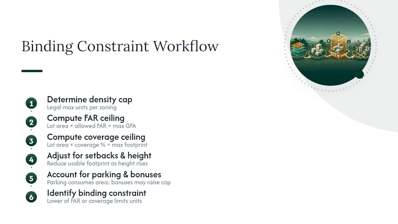
A density cap tells you the maximum unit count. It rarely tells you whether you can actually build that many units, because Floor Area Ratio, lot coverage, setbacks, height limits, and parking requirements each impose their own ceiling, and the lowest one wins.
Floor Area Ratio (FAR) sets the maximum gross floor area as a multiple of lot area. Multiply lot area by the allowed FAR to get your ceiling: a 20,000 square foot lot with a 1.5 FAR allows up to 30,000 square feet of gross floor area, regardless of how many units the density cap technically permits.
Lot coverage limits the building footprint as a percentage of lot area. A 40% coverage limit on that same 20,000 square foot lot caps the footprint at 8,000 square feet, meaning you would need roughly four stories to use up your full FAR allowance.
Setbacks carve out the perimeter of the lot from any building envelope, and many codes increase setback requirements as building height increases, which can quietly shrink your footprint just as you add the extra stories you needed to hit your FAR target.
Parking requirements consume either land area (surface lots) or floor area (structured parking), and in denser multi-family projects, parking is frequently the requirement that eliminates the most potential units, not the density cap itself.
Density bonuses, often tied to affordable housing set-asides or transit proximity, can raise the base cap, but they typically come with their own compliance conditions and unit-counting rules that need separate verification.
To find your actual binding constraint, calculate the FAR-based maximum floor area and the coverage-based maximum floor area separately, then take whichever number is lower. That lower figure, not the density cap, usually determines what you can build.
Pro Tip: Run the FAR and coverage numbers before you fall in love with a unit count. Developers who lead with "the zoning allows 40 units" and only check FAR and parking afterward are the ones who end up redesigning a project mid-entitlement.
Local definitions of gross floor area vary too. Some jurisdictions exclude balconies, mechanical rooms, or below-grade parking from the FAR calculation; others count them fully. Confirm the local definition before you build a pro forma around a FAR assumption borrowed from a different city's code.
Worked Examples: Density Math From Small Lot to Multi-Family
Small suburban lot. A 12,000 square foot lot in an R2 zone allowing 6 DU/acre: 12,000 ÷ 43,560 = 0.275 acres. At 6 DU/acre, that yields 1.65 units, which rounds down to one principal unit, plus whatever ADU allowance the code separately grants.
2.5-acre site with constraints. Gross area is 2.5 acres (108,900 sq ft). A 15-foot road right-of-way dedication and a drainage easement remove 9,000 sq ft combined. Net developable area: 99,900 sq ft, or 2.29 acres. At a zoning cap of 10 DU/acre applied to gross acreage, the theoretical maximum is 25 units. If the code applies the cap to net acreage instead, the maximum drops to roughly 22.9 units, which rounds to 22.
Multi-family binding constraint check. A 1-acre (43,560 sq ft) parcel zoned for 1.0 FAR and 50% lot coverage:
Here, the coverage limit and parking requirement together determine the real building envelope well before FAR becomes the binding factor, even though a density-only calculation might have suggested more units fit.
"Passes the zoning cap" and "practical yield" are two different milestones. The first confirms you are under the numeric DU/acre ceiling. The second confirms the site's FAR, coverage, setbacks, and parking can physically accommodate that count, which is where most theoretical density numbers quietly shrink.
Online Density Calculators: What They Check and What They Miss
Four categories of tools cover most quick-check needs. Address-level density lookups estimate households per acre using census block aggregation, useful for neighborhood comparisons but not parcel-specific answers. Units-per-acre calculators take your acreage and zoning cap and return a theoretical maximum. FAR and coverage calculators layer in floor area and footprint limits. Setback and buildable-envelope tools model the usable building area after required yards are removed.
Each needs specific inputs to be worth running:
- Parcel square footage or acreage, pulled from a survey
- The zoning district's numeric density, FAR, or coverage limit
- Setback dimensions from the local code
- Proposed unit count and parking ratio
The limitations matter more than the outputs. Buildable-envelope tools generally don't account for easements, topography, or title restrictions, and address-level density lookups reflect census geography rather than your actual parcel boundary. Setback requirements often scale with building height too, which most basic calculators don't model dynamically. Treat every calculator output as a screening number, not a final answer, and verify it against the actual municipal code and a current survey before it informs a purchase decision or a pro forma.
When to Hire a Professional for Density and Feasibility Review
A calculator answers "how many units does the code allow." It cannot tell you whether a title exception blocks half your buildable area, whether a floodplain map redraw is coming, or whether an overlay district layers additional restrictions on top of the base zoning. That gap is where a feasibility study earns its cost.
A proper feasibility study typically includes survey and GIS mapping of the actual parcel boundary, title and easement review, zoning interpretation against the specific code language (not a generic summary), binding-constraint analysis across FAR, coverage, setbacks, and parking, and an entitlement strategy for whatever rezoning or variance the numbers require.
Certain site conditions should push you toward professional review immediately, rather than after a calculator gives you an encouraging number: layered or unusual easements, historic or environmental overlay districts, any hint of prior contamination, and floodplain or wetland designations that could shrink net developable area significantly.
Before that first consultation, gather the recorded plat, a current boundary survey, the title report, the zoning map excerpt covering your parcel, and any prior approvals or variances on file with the jurisdiction.
Pro Tip: If you can't find a recent survey, get one before you commission anything else. Every other document, from the title report to the zoning interpretation, is only as accurate as the boundary it's measured against.
Reading Density Numbers in Real Planning Decisions
A DU/acre figure only becomes useful once you place it against the decision it's meant to inform. Planners use density caps to manage traffic generation, school capacity, and utility loads across a district, not to judge whether any single building looks appropriate on its lot. That distinction trips up a lot of first-time applicants who assume a low density number signals a design problem when it's really a capacity constraint.
Context changes what a given number means. Twelve DU/acre next to a transit corridor reads as underbuilt in most planning frameworks; the same twelve DU/acre on the edge of a rural subdivision might already be pushing against septic and well capacity. The number itself carries no judgment until you know what infrastructure, transportation network, and neighborhood pattern surround it.
This is also where gross versus net treatment shows up again in a different form. A jurisdiction that reports density using gross acreage for planning purposes, while permitting builders to calculate net density for entitlement purposes, can produce two defensible numbers for the same parcel. Neither is wrong. They answer different questions: one is a policy metric, the other a buildability test.
Two sites with matching DU/acre numbers can also look nothing alike physically. Twenty units per acre arranged as small-lot single-family homes reads very differently from twenty units per acre stacked into a three-story apartment building, even though the math behind both is identical. Density measures intensity of use, not building form, and mixing up the two is a common source of neighborhood pushback during public hearings.
How Density Numbers Drive Infrastructure and Service Planning
Every unit added to a parcel adds measurable load somewhere else in the system, and density calculations are the input municipalities use to size that load in advance. Water and sewer capacity gets planned around projected unit counts within a service area, not the individual project in isolation, which is why an infill project that looks fine on paper can still trigger a capacity study if it pushes the surrounding grid past a threshold.
Traffic generation follows a similar logic. Transportation departments apply trip-generation rates per unit type to a project's density figure to estimate the added vehicle trips a development will introduce, and that number feeds directly into whether a road widening, a signal upgrade, or a turn lane gets required as a condition of approval.
School capacity planning works the same way in growing districts, where projected dwelling units convert to projected enrollment using local generation rates, and stormwater infrastructure sizing depends on impervious surface, which climbs directly with unit count and coverage.
None of this changes the math behind your DU/acre figure, but it explains why a jurisdiction might cap density well below what a site could physically support. The cap often reflects a shortfall in a pipe, a road, or a school seat somewhere else in the network, not a judgment about your specific parcel. Understanding that helps explain why an appeal based purely on "the math works" rarely succeeds without also addressing the infrastructure question the jurisdiction is actually worried about.
Density Calculation Methods Across Different Jurisdictions
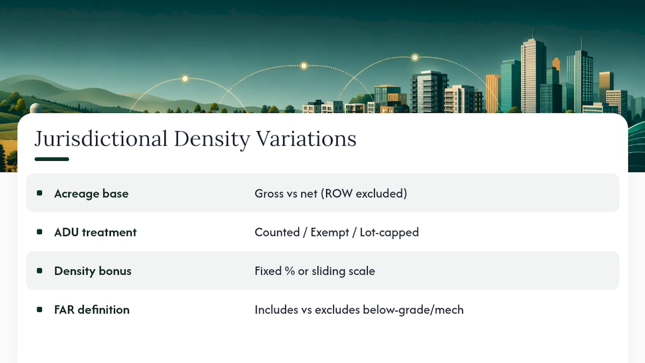
The core DU/acre formula stays consistent almost everywhere, but how jurisdictions apply it varies enough to trip up developers working across state lines or even across neighboring counties within the same state. Some codes calculate density strictly against gross parcel acreage with no deductions. Others mandate net acreage calculations that automatically exclude rights-of-way and easements before the density math even starts.
ADU treatment is one of the sharpest points of divergence. Some jurisdictions count every ADU as a full unit against the cap. Others exempt ADUs entirely, treating them as a housing policy tool separate from base zoning density. A handful cap the number of ADUs per lot regardless of underlying density, which functions as a de facto unit limit independent of the DU/acre figure altogether.
Density bonus programs differ just as much. Some tie bonus density to a fixed percentage increase in exchange for affordable units; others use a sliding scale tied to the percentage of affordable units provided, which changes the math on a per-project basis rather than applying a flat multiplier.
Floor area ratio definitions add another layer of regional variation, with some codes excluding features like below-grade parking or mechanical space from the FAR calculation while others count them fully. A FAR assumption that holds true in one municipality's code can produce a meaningfully different buildable envelope in another, even when the numeric FAR figure looks identical on paper. None of this is a reason to distrust the base formula, but it is a strong argument for reading the specific local ordinance language rather than assuming density math travels cleanly across jurisdiction lines.
A Planner's View: Density Is One Input, Not the Answer
In feasibility work, density is the first filter, not the final verdict. It tells you whether a site is worth the next round of diligence, but the theoretical DU/acre number and the practical, buildable unit count are rarely the same figure once FAR, coverage, parking, and easements enter the picture.
The gap between those two numbers is where most project timelines and budgets actually get decided. My recommendation: run the basic math yourself first to screen the site, then pull the survey, the title report, and the zoning code's exact language before you commit capital to a unit count. If those documents raise more questions than they answer, that is the moment to bring in a planner for a formal feasibility review rather than after a design is already on paper.
— Jeremy Wenger
Turn Your Density Number Into a Buildable Plan
A calculator gives you a ceiling. Urban Planning Pros gives you the buildable number, verified against your actual survey, title, and zoning code, before you spend money on architecture or capital raises based on a theoretical DU/acre figure that never accounted for the easement running through your parcel.

A typical feasibility engagement starts with document collection: your plat, survey, title report, and any prior zoning approvals. From there, our team runs GIS mapping and zoning interpretation against the binding constraints covered above, FAR, coverage, setbacks, and parking, to identify what your site can actually support, not just what the density cap theoretically allows. Clients walk away with a clear entitlement strategy and a realistic unit count before they buy, sell, or break ground. If your next move depends on a number you can defend to a lender, a partner, or a planning board, start with a feasibility study and get that number in writing.
Sources
For quick verification, the Zoning Density Calculator covers the DU/acre formula and acreage conversion. The FAR, Lot Coverage & Parking Calculator handles binding-constraint math. For neighborhood-scale comparisons, CNT's Residential Density tool uses census data. For process context outside the density math itself, see this development application overview.
FAQ
What Is the Formula for Calculating Density?
Density (DU/acre) equals the number of dwelling units divided by the site area in acres. Convert square feet to acres first by dividing by 43,560.
What Are the Three Density Formulas Planners Use?
The three most common are dwelling units per acre (DU/acre), which measures housing intensity; population density per acre, which measures people rather than units; and Floor Area Ratio, which measures allowable gross floor area relative to lot size rather than unit count directly.
How Many Apartments Can You Fit on 2.5 Acres?
It depends entirely on the zoning cap and binding constraints, not acreage alone. At a 10 DU/acre gross density cap, 2.5 acres theoretically allows 25 units, but FAR, lot coverage, setbacks, and parking requirements typically reduce that practical number, sometimes significantly, once easements and rights-of-way are subtracted.
What Is Density Per Acre and Why Does It Vary by Site?
Density per acre is the unit count divided by site acreage, but the practical figure varies because gross versus net acreage treatment, easements, and zoning modifiers like FAR and parking requirements all change how many units a given acre can actually support.
When Should I Get a Professional Feasibility Study Instead of Using a Calculator?
Commission a feasibility study when a site has easements, floodplain or wetland exposure, an overlay district, or any title complication, since calculators generally can't account for these constraints and a wrong assumption at the purchase stage is far more expensive to fix later.