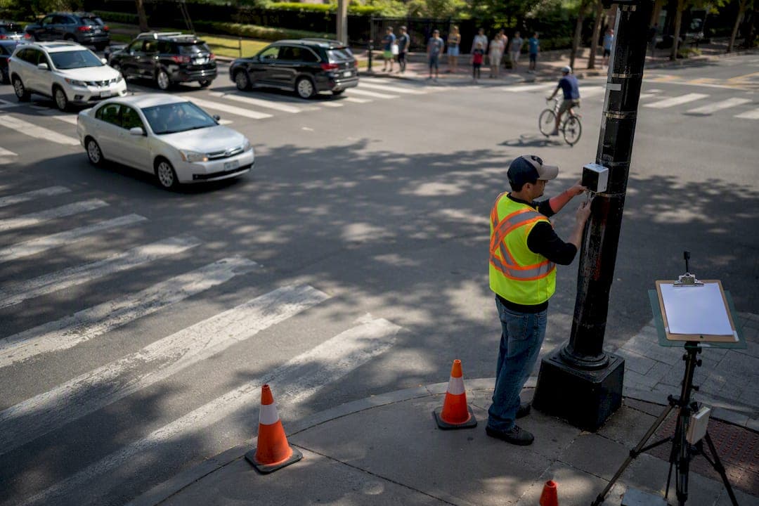
A traffic impact analysis (TIA) is a technical, evidence-based study that quantifies a proposed development's vehicle, pedestrian, freight, and transit impacts and shows what mitigation, if any, is needed. It provides an engineering-based assessment of impacts on safety, congestion, and roadway capacity, and agencies use it to determine whether developer contributions are warranted. Most jurisdictions tie the requirement to a trip-generation threshold, a rezoning application, or a driveway/access permit.
If your project is anywhere near a peak-hour trip threshold, don't wait for the agency to raise it. Reach out early.
- Request a scoping or pre-application meeting with the reviewing jurisdiction before finalizing site plans.
- Ask whether a full report, a technical memo, or a letter of opinion applies to your project size.
- Confirm which horizon years, peak periods, and study intersections the agency expects to see.
Key Takeaways
A defensible traffic impact analysis depends on early scoping, HCM-based operations analysis, documented assumptions, and clear separation of project trips from background growth.
| Point | Details |
|---|---|
| Start with scoping | Request a pre-application meeting before finalizing site plans to confirm study area, peak hours, and required deliverable type. |
| Follow the standard sequence | Move through data collection, trip generation, distribution, TMV tables, and HCM-based operations analysis in order. |
| Match tools to project risk | Use Synchro, HCS, or Sidra for standard capacity work and reserve microsimulation for complex queuing or weaving conditions. |
| Separate project and background traffic | Document background growth and nearby approved developments distinctly so mitigation costs stay proportionate. |
| Plan for reevaluation | Revisit the analysis if phasing changes, timelines extend significantly, or an agency requires post-opening monitoring. |
Table of Contents
- What Is a Traffic Impact Analysis and How Does the Process Work?
- What Standards and Software Do Reviewers Expect?
- When Does a Project Actually Require a TIA?
- What Belongs in the Final Traffic Impact Report?
- How Urban Planning Pros Approaches a Defensible TIA
- Why Does Public Input Matter in a Traffic Study?
- How Should Multimodal Impacts Factor Into the Analysis?
- What Role Do New Data Sources Play in Modern TIAs?
- How Do Traffic Impacts Connect to Environmental and Land Use Review?
- What Legal Exposure Comes With a TIA's Findings?
- When Does a TIA Need to Be Updated or Redone?
- What Should Developers Prioritize First in a TIA?
- Frequently Asked Questions
- Sources
What Is a Traffic Impact Analysis and How Does the Process Work?
A TIA moves through a defined sequence, and skipping steps is the fastest way to get a report bounced back for revisions. The process typically involves defining the scope, collecting traffic data, estimating project-generated trips, distributing those trips across the network, and evaluating future operations to decide whether mitigation is required. Each step produces a specific output the reviewer will look for by name, so treating this as a checklist rather than a narrative saves rework later.
- Scope the study. Define the study area, peak hours (typically AM and PM weekday peaks, sometimes Saturday midday for retail), horizon years, and which agency guidance governs. Get this in writing during a pre-application or scoping meeting.
- Collect field data. Gather turning-movement counts at study intersections, mainline link counts, existing geometry, signal timing plans, and multimodal counts (pedestrian and bicycle volumes at key crossings).
- Estimate trip generation. Apply rates from the ITE Trip Generation Manual for the proposed land use and size, and note where pass-by or internally captured (linked) trips reduce net new volume. Local trip counts from comparable sites are appropriate when a use type is uncommon in the manual or the local context differs materially.
- Distribute and assign trips. Spread new trips onto the network based on existing travel patterns, gravity-model logic, or agency-supplied distribution percentages, then assign them to specific turning movements at each intersection.
- Build turning-movement volume (TMV) tables. Combine existing counts, background growth, nearby approved development traffic, and project trips into a scenario-by-scenario table for each intersection.
- Run the operations analysis. Use Highway Capacity Manual methods to calculate Level of Service, delay, and queue lengths for each scenario. Microsimulation becomes worthwhile when queues spill between closely spaced signals or a corridor has complex weaving.
- Test mitigation. Rerun the analysis with proposed turn lanes, signal timing adjustments, or access modifications to show the improvement numerically, not just descriptively.
Pro Tip: Build your TMV tables in a format that separates background growth, nearby approved projects, and your project's trips into distinct columns. Reviewers spot commingled numbers immediately, and it is the single most common reason a report gets sent back for clarification.
What Standards and Software Do Reviewers Expect?
Reviewers are trained to recognize certain reference points, and a report built on unfamiliar methodology invites scrutiny even when the math is sound. The ITE Trip Generation Manual remains the default source for trip rates, though most agencies allow substitution of locally collected data when a land use is unusual or a published rate is known to be unreliable for the local market. The Highway Capacity Manual (HCM) is the near-universal basis for intersection and segment capacity analysis, with microsimulation reserved for cases where HCM's steady-state assumptions break down.
- Capacity analysis: Synchro, HCS, and Sidra are the common tools reviewers see for HCM-based signal and intersection analysis.
- Microsimulation: Vistro and similar packages model queuing and network interactions that static methods miss.
- Background forecasts: MPO travel demand models, state DOT count programs, and adopted comprehensive plans supply the growth rates and nearby-development data.
State DOT manuals typically require HCM-based capacity analysis, specify which software packages are pre-approved, and require sign-off before an applicant substitutes an alternative tool. WisDOT's guidance, for example, names Synchro, HCS, Sidra, and Vistro explicitly and requires justification for anything outside that list.
When Does a Project Actually Require a TIA?
Thresholds vary by jurisdiction, but a commonly cited baseline is when a development generates new peak-hour trips onto the adjacent street network, a figure referenced in transportation planning guidance from the University of Connecticut's Connecticut Transportation Institute. Some cities set the bar lower for sensitive corridors near schools or intersections already operating near capacity, and some set it higher for industrial zones with predictable, low-frequency truck traffic.
- Horizon years commonly run 10 years after opening or 5 years past full buildout, following scenario-based practices in state guidance.
- Phased projects usually need interim analyses for each major phase, not just a single buildout scenario.
- A pre-scope meeting, followed by draft and final report submissions, is standard; VDOT publishes pre-scope forms and checklists specifically to standardize this intake.
- Related approvals, including driveway or entrance permits, rezoning cases, and environmental reviews, often run on parallel or dependent timelines, so a TIA delay can stall the whole entitlement.
Start the TIA during concept or preliminary design, not after site plans are locked. That timing lets you adjust access points, parking layout, and internal circulation before those decisions become expensive to unwind, a sequencing point emphasized in TxDOT's TIA process guidance.
What Belongs in the Final Traffic Impact Report?
A complete traffic impact report needs an executive summary, a study area map, TMV tables for every scenario, a methodology section naming the software and version used, documented assumptions, and exhibits showing existing and proposed geometry. Not every project needs the full package. TxDOT's own guidance notes that a technical memo or letter of opinion can satisfy reviewers for lower-impact projects when that scope is agreed upon during the scoping meeting.
- Document every assumption explicitly. Growth rates, distribution percentages, and pass-by capture rates all need a stated source, not just a number.
- Separate your project's impact from background traffic. High-quality TIAs isolate project trips from background growth and nearby approved developments so mitigation costs land proportionately, not entirely on the last applicant in line.
- Match your analysis depth to project risk. Running full microsimulation on a low-complexity site wastes budget and invites questions about scope; skipping it on a congested, multi-phase corridor invites rejection. MoDOT's guidance frames this as matching method to risk, not defaulting to the most sophisticated tool available.
- Present mitigation as specific, testable changes. Name the turn lane, the signal phase change, or the crosswalk relocation, and show the before-and-after LOS numbers. Skip cost allocation in the report itself; that belongs in a separate negotiation with the agency.
How Urban Planning Pros Approaches a Defensible TIA
Urban Planning Pros starts traffic scoping alongside feasibility work, not after it, so site constraints identified in due diligence inform trip generation assumptions from day one. That sequencing matters because access points, parking counts, and building footprint all shift trip generation numbers, and revising a TIA after site plans are locked costs more than getting the sequence right the first time.
- Feasibility findings and survey and GIS mapping feed directly into the study area exhibits reviewers expect.
- Pre-application coordination happens before draft submission, reducing the odds of a scoping dispute mid-review.
- Clients typically receive an executive snapshot, TMV exhibits, and a mitigation package, with microsimulation added only when corridor complexity justifies it.
Pro Tip: Ask your consultant to walk through the mitigation package before it goes to the agency. A recommendation that reads clearly to an engineer sometimes reads as vague or unfunded to a planning commissioner, and that gap causes avoidable delays.
Why Does Public Input Matter in a Traffic Study?
Agencies increasingly fold public comment periods into TIA review, particularly for rezonings or projects near residential neighborhoods, because a technically sound report can still generate political friction if residents feel blindsided. Planning commissions and city councils often hold the final vote on whether proposed mitigation is adequate, and their comfort level depends partly on whether neighbors had a chance to raise concerns about cut-through traffic, school-zone safety, or construction-phase disruption.
Smart applicants get ahead of this rather than treating public hearings as a formality to survive. Sharing a plain-language summary of projected trip volumes and proposed mitigation before the formal hearing, sometimes at a neighborhood meeting the applicant organizes voluntarily, tends to surface concerns early enough to address them in the report rather than in a contentious hearing.
Stakeholder input often catches real gaps a technical team misses. Residents know which intersection backs up during school pickup even when count data from a random Tuesday in October does not capture it. Transit agencies know which routes are slated for frequency changes that will affect your assumptions about mode share. Bicycle and pedestrian advocacy groups often flag safety concerns at specific crossings that a vehicle-focused study can overlook entirely. Folding that input into the analysis, rather than treating it as an obstacle to manage, generally produces a more defensible report and a smoother path through public hearings.
How Should Multimodal Impacts Factor Into the Analysis?
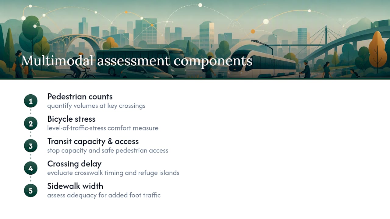
Basic multimodal accommodation, a sidewalk here, a bike rack there, no longer satisfies most reviewers in growing metro areas. A genuine multimodal traffic assessment study quantifies pedestrian and bicycle volumes at key crossings, evaluates whether existing crosswalk timing and refuge islands can absorb added foot traffic, and checks whether nearby transit stops have adequate capacity and safe pedestrian access from the new development.
This matters most for mixed-use and infill projects where a meaningful share of trips will not be vehicle trips at all. If a development sits within a quarter mile of a transit stop, some jurisdictions expect a mode-share adjustment that reduces the assumed vehicle trip generation, but that adjustment needs its own supporting data, not just an assumption pulled from a general transit-oriented development multiplier.
Pedestrian level of service, measured through crossing delay and sidewalk width adequacy, is increasingly requested alongside vehicle LOS in dense corridors. Bicycle level of traffic stress, a separate framework assessing how comfortable a cyclist would feel on a given roadway, shows up in some progressive jurisdictions' scoping requirements now too. Treating these as afterthoughts once the vehicle analysis is done usually produces a bolted-on multimodal section that reviewers can spot instantly, and it typically triggers a request for revision.
What Role Do New Data Sources Play in Modern TIAs?
Traditional manual turning-movement counts still anchor most TIAs, but the data landscape supporting them has changed. GPS-derived travel data from mobile devices and connected vehicles now supplements or, on some corridors, substitutes for manual counts, particularly useful for capturing travel patterns across a wider study area than a two-day manual count could realistically cover. Some agencies accept this data for background traffic estimation while still requiring manual counts at the specific study intersections.
Permanent traffic sensors embedded in roadways or mounted on signal poles increasingly provide continuous count data that can validate or adjust the short-duration counts a TIA typically relies on. This matters because a two-hour peak-period count taken on an atypical day can skew an entire analysis, and continuous sensor data lets a reviewer sanity-check that the count period was representative.

Microsimulation software has also become more accessible for mid-size projects, not just megaprojects. Where it once required specialized modeling staff and weeks of calibration, current tools let a competent traffic engineer build and run a corridor model in days when queue interactions or closely spaced signals make HCM's static methods unreliable. The judgment call is still the same one MoDOT's guidance frames directly: match the tool to the actual complexity of the site, not to what looks impressive in a report.
How Do Traffic Impacts Connect to Environmental and Land Use Review?
Traffic findings rarely stay contained to a transportation section once a project needs environmental review. Projected vehicle volumes feed directly into air quality modeling, since idling and congestion at failing intersections increase localized emissions, and some jurisdictions require this link explicitly when a project falls under state environmental review thresholds. Noise studies draw on the same trip generation and distribution numbers to project future decibel levels along affected corridors, which then factor into required setbacks or sound barriers.
Land use compatibility reviews also lean on TIA findings more than developers often expect. A rezoning application that would introduce a use generating substantially more traffic than the surrounding roadway network can absorb may face land use objections that are really traffic objections in disguise. Conversely, a well-documented TIA showing that a proposed use generates fewer peak-hour trips than the existing zoning would allow by right can become a persuasive argument for a rezoning, not just a compliance hurdle to clear.
Stormwater and impervious surface calculations tied to new turn lanes or widened approaches also loop back into site plan review, since additional pavement changes the drainage calculations elsewhere in the application. Coordinating the traffic engineer with the civil engineer and environmental consultant early avoids a scenario where mitigation proposed in the TIA conflicts with a stormwater constraint discovered later in review.
What Legal Exposure Comes With a TIA's Findings?
A TIA's conclusions carry real legal weight once they enter the public record, and that record can resurface in ways applicants do not always anticipate. If an approved development later contributes to documented safety problems at a study intersection, the TIA becomes evidence in any subsequent liability discussion, which is one reason overly optimistic trip generation assumptions or thin mitigation justifications create risk beyond just review delays.
Disputes over TIA findings typically surface in one of two ways. Neighbors or advocacy groups sometimes challenge a report's conclusions during the public hearing process, arguing that trip generation was undercounted or that proposed mitigation is inadequate, which can trigger a formal appeal of the approval decision. Applicants, on the other hand, sometimes challenge an agency's requirement to fund off-site mitigation they believe is disproportionate to their project's actual impact, arguing the agency is allocating background growth or other developments' fair share onto a single applicant.
This is exactly why separating project-generated trips from background growth and nearby approved development traffic matters as more than technical hygiene. A report that clearly documents which impacts belong to the project versus the surrounding network gives an applicant firmer ground to contest disproportionate mitigation demands, and it gives an agency firmer ground to defend a reasonable mitigation requirement if challenged. Vague or commingled assumptions leave both sides exposed.
When Does a TIA Need to Be Updated or Redone?
A TIA is not a one-time document filed away after approval. Development timelines routinely run long enough that the traffic conditions assumed at approval no longer match conditions at construction, and several triggers should prompt a formal re-evaluation rather than an assumption that the original findings still hold.
Significant phasing changes are the most common trigger. If a project approved as a single phase gets rebuilt as a multi-year phased development, or if the mix of uses shifts substantially (more retail square footage, fewer office units, an added drive-through), the original trip generation numbers no longer describe what is actually being built. Most jurisdictions require an updated analysis, at minimum a memo comparing revised trip generation against the approved figures, before issuing permits for a materially changed later phase.
Extended timelines matter too. A TIA approved with a 10-year horizon assumes background growth rates that were reasonable at the time of the study. If construction stalls for several years, nearby development that was speculative during the original scoping meeting may now be built and operating, changing the baseline conditions the original mitigation was sized against. Agencies increasingly ask for a traffic conditions update, not a full re-study, in this scenario, comparing current counts against the assumptions baked into the original approval.
Post-construction monitoring is less common but growing, particularly for large or controversial projects, where an agency conditions approval on a follow-up traffic count within a year or two of opening to confirm the mitigation performed as modeled. If it did not, additional measures can be required as a condition of final occupancy or a subsequent phase's approval.
What Should Developers Prioritize First in a TIA?
The conventional advice treats a TIA as a compliance exercise: hit the trip threshold, hire an engineer, submit the report, move on. That undersells what a well-built analysis can do for a project. The developers who get the smoothest approvals are the ones who use the TIA to negotiate, not just to comply, documenting exactly which impacts are theirs and which belong to background growth or a neighboring project already in the pipeline.
Where most reports fall short is documentation of assumptions, not math. Reviewers rarely reject a TIA because the HCM calculations are wrong. They reject it because a growth rate or distribution percentage appeared without a stated source, and that gap invites doubt about everything else in the report.
If you take one thing from this guide, prioritize the scoping meeting over the analysis itself. A poorly scoped TIA, even one built with flawless methodology, gets rejected for answering the wrong question. Get agreement on study area, horizon years, and deliverable type in writing before your engineer runs a single count.
Frequently Asked Questions
What is the difference between a traffic impact study and a traffic impact analysis? The terms are used interchangeably in most jurisdictions. Some agencies use "traffic impact study" for the full formal document and reserve "traffic impact analysis" for the underlying technical work, but there is no universal distinction, and you should follow whatever term your reviewing agency uses in its guidance.
How long does a traffic impact analysis typically take to complete? Timelines vary with project complexity and data collection needs, but expect several weeks for data collection and analysis, plus additional time for agency review of draft and final submissions. Starting during concept design, rather than after site plans are finalized, gives you the most flexibility if results require access or layout changes.
Can a small project avoid a full traffic impact report? Often, yes. Many agencies accept a technical memo or letter of opinion for lower-impact projects when that reduced scope is agreed upon during a pre-application or scoping meeting rather than assumed unilaterally.
Who reviews and approves a traffic impact analysis? Typically the local jurisdiction's traffic engineering or public works department, sometimes in coordination with the state DOT if state-maintained roadways are affected. Larger or contested projects may also involve the planning commission or city council as part of a rezoning or site plan approval.
Does a traffic impact analysis determine who pays for road improvements? It identifies what mitigation is needed and how impacts are distributed among the project, background growth, and nearby developments, but cost allocation and funding mechanisms are typically negotiated separately with the agency rather than dictated by the report itself.
Ready to bring traffic analysis into your next project's due diligence from the start? Urban Planning Pros integrates feasibility studies, survey coordination, and traffic scoping into a single workflow so your entitlement submission holds up under review. Start with a feasibility study to see how your site's traffic obligations connect to zoning, access, and market positioning before you commit to a design.
Sources
- Chapter 16 Traffic Impact Analysis — TxDOT
- WisDOT traffic impact analysis guide (tracked 2024)
- Traffic impact analysis | Virginia Department of Transportation
- Traffic Impact Assessment: A Step-by-Step Guide — Transoft Solutions